All Services

Spatial Analysis
| |
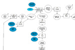 Spatial analysis and geoprocessing tasks are a distinctive of GIS. GEO/Graphics has years of collective experience
in applying spatial analysis to solve real-world problems, and to help project managers generate summaries and reports for their data.
We use tools such as ESRI Modelbuilder, Python, and SQL to help streamline and document complex analyses.
Spatial analysis and geoprocessing tasks are a distinctive of GIS. GEO/Graphics has years of collective experience
in applying spatial analysis to solve real-world problems, and to help project managers generate summaries and reports for their data.
We use tools such as ESRI Modelbuilder, Python, and SQL to help streamline and document complex analyses.
|
Facilities
GIS is an ever-changing discipline, and GEO/Graphics strives to keep abreast
with the technology. We have access to and expertise in:
ArcGIS Desktop (ArcInfo)
Spatial Analyst
3D Analyst
ArcGIS Server
ArcSDE
Google Earth Professional
Manifold Systems GIS
AutoCAD
ER Mapper
Erdas Imagine
Leica Photogrammetry Suite
Inpho Orthovista
SQL Server
Adobe Creative Suite
Microsoft Visual Studio
Windows XP Pro
Windows Vista x64
Windows Server 2003
Windows Server 2008
HP Plotters and Printers
SCSI Backup Devices
Trimble GPS Receivers