GEO/Graphics, Inc.
Home
435-753-5429
skip to the main content area of this page
Home
Services
Staff
Projects
About
Contact
Services
All
Services
GIS Consulting/Contracting
Data Capture
Database Design
Spatial Analysis
Linear Network Modeling
Scripting and Automation
Cartography
Press-Quality Maps
Atlas Production
Plotting
GPS Surveying
Ortho Planning
Resource Mapping
Image Processing
Orthophotography
Mosaicking/Compression
Training
GIS Training
GPS Training
Orthophotography
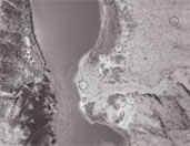
GEO/Graphics uses Leica Photogrammetry Suite to process detailed terrain models and orthophotos. We have the expertise and facilties to complete an ortho project from start to finish.
Facilities
GIS is an ever-changing discipline, and GEO/Graphics strives to keep abreast with the technology. We have access to and expertise in:
ArcGIS Desktop (ArcInfo)
Spatial Analyst
3D Analyst
ArcGIS Server
ArcSDE
Google Earth Professional
Manifold Systems GIS
AutoCAD
ER Mapper
Erdas Imagine
Leica Photogrammetry Suite
Inpho Orthovista
SQL Server
Adobe Creative Suite
Microsoft Visual Studio
Windows XP Pro
Windows Vista x64
Windows Server 2003
Windows Server 2008
HP Plotters and Printers
SCSI Backup Devices
Trimble GPS Receivers
 GEO/Graphics uses Leica Photogrammetry Suite to process detailed terrain models and orthophotos. We have the
expertise and facilties to complete an ortho project from start to finish.
GEO/Graphics uses Leica Photogrammetry Suite to process detailed terrain models and orthophotos. We have the
expertise and facilties to complete an ortho project from start to finish.